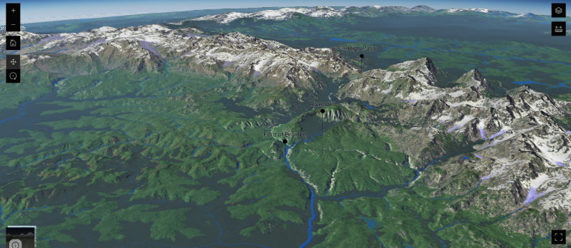
The level of detail is incredible. There are both 2D and 3D versions of the map that you can zoom in on and fly around like a modern digital map. Here’s a view of Rivendell and the nearby Misty Mountains from the 3D version.
The Middle-Earth Map is a project Micah Vander Lugt, a geographic information sciences analyst. It’s great to see people put their professional skills to work on hobbies that they’re passionate about!
Hey, look! We found a thing on the internet! We thought it was cool, and wanted to share it with you.
The Villa Farnese is a gorgeous Renaissance palace in central Italy, built in the early 1500s and richly elaborated with sculptures and frescoes. One of the rooms in the villa features a map of the world filling the wall at one end, with detailed maps of the continents on the other walls, under a ceiling decorated with constellations. Standing in this room, the magnates of the villa could see the whole world, as it was known to scientists and cartographers of the day.
The map room at Villa Farnese, photograph by Etienne (Li) via Wikimedia (Caprarola, Italy; completed 1574; fresco; by Giovanni Antonio de Varese)
Looking at this space, it occurs to me that a room like this would make an excellent setting for a scene in a fantasy or historical story. Many such stories play out over long distances, and knowing how one territory or city relates to the others around it as well as to the shapes of the land can make a huge difference in understanding the stakes and possibilities in play.
Africa, from the map room at Villa Farnese, photograph by Jean-Pierre Dalbèra via Wikimedia (Caprarola, Italy; completed 1574; fresco; by Giovanni Antonio de Varese)
In a visual medium like tv or movies, it could be very helpful to have a visual in the background while characters are discussing important movements or plans, but even in text, putting your characters in such a place could give you an opportunity to describe them looking at the map, tracing routes of travel or the borders between nations, and arguing for their plans.
Europe, from the map room at Villa Farnese, photograph by Ulrich Mayring via Wikimedia (Caprarola, Italy; completed 1574; fresco; by Giovanni Antonio de Varese)
Maps make everything better!
History for Writers looks at how history can be a fiction writer’s most useful tool, from worldbuilding to dialogue.
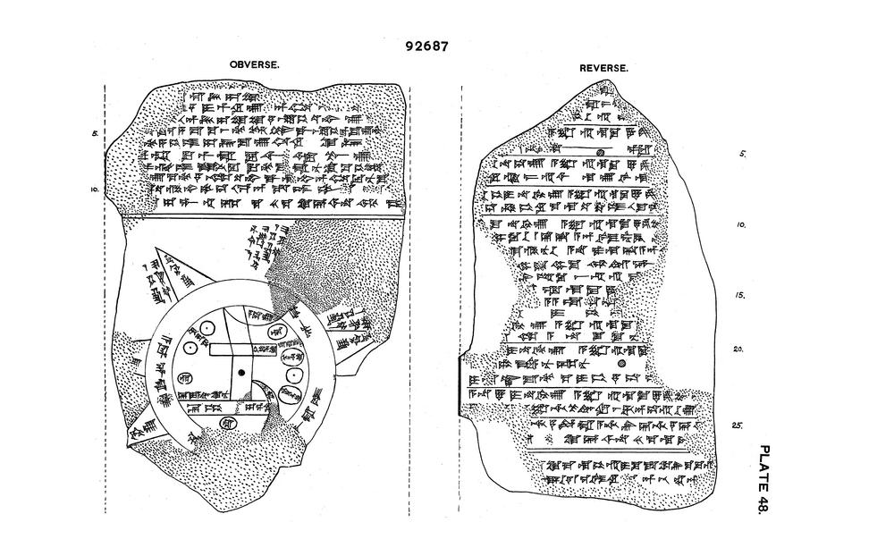
The Map of the World, Late Babylonian (found Abu Habba (Sippar), currently British Museum; c. 6th c. BCE; clay)
The map shows the world as a disc surrounded by the circular “Bitter River”. Babylon is marked as a rectangle, the river Euphrates flows south in the middle, and small circles show cities or districts.
The curator’s comment in the BM catalog says that according to the tablet it was copied from an earlier one. Clearly there was an established practice by 6th c. BCE—this object is quite recent in Mesopotamian terms, after all.
Obviously, the map was meant to be more conceptual than realistic. However, there are many notes (and even some time / linear measurements) which make it more usable. (Please visit BM and read the item description; it’s quite fascinating.)
The Map of the World, Late Babylonian (found Abu Habba (Sippar), currently British Museum; c. 6th c. BCE; drawing of clay tablet)
What an intriguing map, isn’t it?
As the fragment is approximately 12 by 8 cm (approx. 3″ x 5″), it’s believable that it could’ve easily been transported if desired. Which makes it quite plausible that intrepid adventurers in a story or role-playing campaign in a similar setting could carry around maps made in the same style. There could quite well be professional mapmakers and a developed cartography for your world, even if writing doesn’t happen on sheets of paper as we know it.
The Visual Inspiration occasional feature pulls the unusual from our world to inspire design, story-telling, and worldbuilding. If stuff like this already exists, what else could we imagine?
Maps tell us where we are and how to get where we’re going. Sometimes, the top-down, bird’s-eye-view style of map we are most used to today is not the most helpful tool for achieving that goal. Anyone who’s had to orient themselves in a strange landscape with a traditional map knows the frustration of trying to match the visible landmarks and shapes of the terrain to the lines and symbols of the map. There are also plenty of places where pulling out a flat paper map would be impractical.
From Greenland comes a different approach to mapping. These drawings show two carved wooden maps of the coastline around the eastern Greenland settlement of Sermiligaaq that were sold to Danish explorers by a local named Kunit in the 1880s.
These small carvings, known as the Ammassalik wooden maps, represent the shapes of the coastline. The narrower map represents a string of islands; the wider one records a stretch of the mainland coastline and is read in a continuous stretch up one side and down the other. They are small enough to be held inside a mitten so that a traveler paddling down the coast by kayak could feel their way along from one bay to the next.
Just another example of how human ingenuity finds different solutions to similar problems.
Creating medieval(esque) city maps just got a lot easier: Oleg Dolya (watabou) made an automated generator to do it.
Choose size of city with the click of a button, and color scheme and line or shading types from the options. You can export the image either as png or svg. Unfortunately the ward names (temple, merchant, crafts, etc.) aren’t saved on the exported map, though.
Watabou also built a 3d-visualiser to support Medieval Fantasy City Generator called Toy Town. Although I haven’t played with that, it sounds like both should be a great help to storytellers—unless you enjoy the process with paper and pen, of course!
Really fascinating! I know there were also some Roman roadworks running at least partially across the land from east to west along Hadrian’s Wall in Britain, but I don’t know whether there ever was a complete major road there.
In Making Stuff occasional feature, we share fun arts and crafts done by us and our fellow geeks and nerds.
“BETTER, BUT NOT FUCKING GOOD! WHATEVER, TRACE THE COASTLINE WITH YOUR PENCIL. BE SURE TO BE SLIGHTLY SQUIGGLY AND, OH, FUCK THOSE LITTLE ISLANDS YOU MADE THEY’RE NOT BIG ENOUGH TO BE WOBBLY ENOUGH SO YOU’RE BETTER OFF USING EITHER RICE (OR SIMILAR) OR JUST TRY TO MAKE SOME REALISTIC FUCKING ISLANDS (SPOILER: YOU WON’T)”
(I find that ohemult’s instructions work best if I imagine Samuel L. Jackson reading them as his Pulp Fiction character.)
The London Picture Archive is a gigantic, free online photo map of the city’s past. The project has been nicknamed Collage.
Managed by London Metropolitan Archives (LMA), the map is made with over 250,000 photos, prints, maps, and drawings from the collections of LMA and Guildhall Art Gallery. Visitors can search by street name, or browse featured galleries and subjects. From the description of Collage:
“The images provide an extraordinary record of London and its people from the fifteenth century to the present day. The whole of Greater London is covered, as are the adjoining counties. Some of the many highlights include photographs of Victorian London; the sixteenth century ‘Agas’ map of London; Hollar’s stunning panorama from 1647; beautifully designed twentieth century posters for London’s tramways; the Cross and Tibbs photographs of Second World War damage to the City of London and the collections formerly held at the Guildhall Print Room. We regularly add new content from the LMA collections and, in particular, continue to develop descriptions and subject tags for the very large London County Council Photograph Library.”
I’ve only poked around for a short time, but for general purposes Collage looks like an endless source of images. For more specific searches it may not do quite so well. It certainly appears to be a worthwhile source for historical or historically inspired worldbuilding.
An autogenerated map for a fantasy world, including slopes, borders, coastlines, rivers, cities, and territories, created with Uncharted Atlas. Coding by Martin O’Leary
Currently mainly existing to feed material to the Uncharted Atlas twitterbot, the tool and its code are available for others as well.
“I wanted to make maps that look like something you’d find at the back of one of the cheap paperback fantasy novels of my youth. I always had a fascination with these imagined worlds, which were often much more interesting than whatever luke-warm sub-Tolkien tale they were attached to.
“At the same time, I wanted to play with terrain generation with a physical basis. There are loads of articles on the internet which describe terrain generation, and they almost all use some variation on a fractal noise approach, either directly (by adding layers of noise functions), or indirectly (e.g. through midpoint displacement). These methods produce lots of fine detail, but the large-scale structure always looks a bit off. Features are attached in random ways, with no thought to the processes which form landscapes. I wanted to try something a little bit different.”
Uncharted Atlas also generates names for cities, towns, and regions with a separate bit of code, following a set of consistent rules. For an explanation of how it works and to try your own hand at it, see the terrain notes and language notes.
As a user, I’d like to see a way to connect several of these individual maps into a larger unity, but that’s getting ahead of things—just having a free tool like this is fantastic. 🙂 Kudos!
In Making Stuff occasional feature, we share fun arts and crafts done by us and our fellow geeks and nerds.
Traveling over land is familiar. Many of us do it every day (even if we don’t do it as part of an army or with pack animals), but travel over water, though vital to the modern economy, isn’t part of daily life for most of us. Sometimes, though, the characters in your stories or games need to ride a raft downriver, strike out across the ocean in an outrigger canoe, or hoist the sails of a ship of the line. In this installment of the travel series, we look at types of pre-industrial water transport, the speeds and distances ships can travel, how much cargo ships can carry, and what it takes to make a successful voyage over water.
Speed
Ship speeds are conventionally measured in knots, equivalent to 1 nautical mile (1.151 statute miles or 1.852 km) per hour. 1 km/h is equal to 0.54 knots. In this post, I have given all speeds in terms of km/h for consistency with the other travel posts.
Types of transport
There are many different types of watercraft, from one-person rafts to massive cargo ships, but one essential way of distinguishing them is by means of propulsion. Pre-modern vessels had four basic options for propulsion: current, wind, paddles/oars, or draft.


_(40968585594).jpg)