Truly Old Buildings at Göbekli Tepe and Karahan Tepe

Among the world’s oldest buildings are the circular and rectangular structures at Neolithic sites known as the Taş Tepeler culture in Upper Mesopotamia or south-eastern Anatolia (modern-day Turkey).
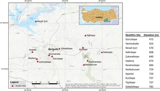
Turkiye Today Tas Tepeler Map Sm

The earliest Taş Tepeler sites were established by hunter-gatherers some 11,000 years ago (10th-9th millennium BCE)—about 6,000 years before Newgrange and Stonehenge. The two best known are Göbekli Tepe and Karahan Tepe. Apart from similar buildings, both these sites also contain the same kind of carvings and statuary of varying sizes depicting both animals and humans, and distinctive T-shaped pillars with shared symbolism.

The Göbekli Tepe site consists of a Neolithic mound (or a tell) with domestic structures and other small buildings, quarries, and stone-cut cisterns.
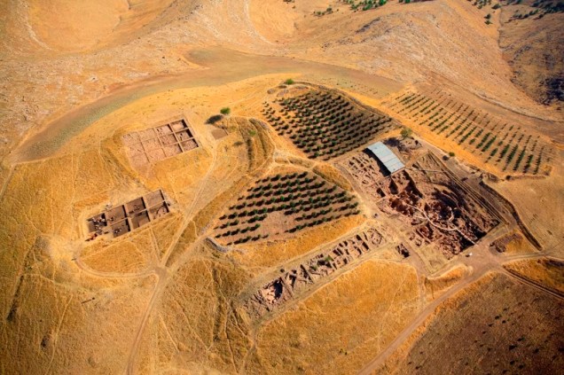
DAI Gobekli Tepe Aerial Sm
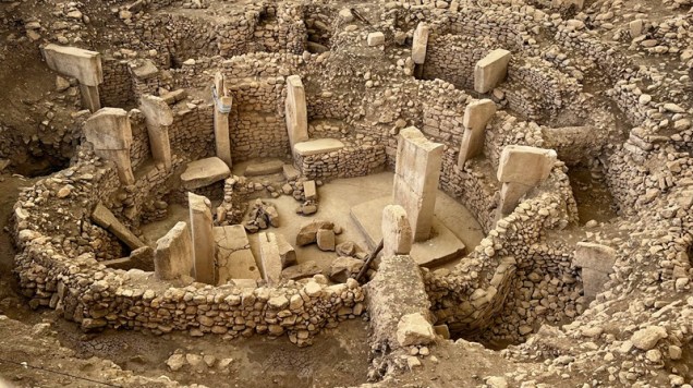
Unsplash Frank Samol Gobekli Tepe Sm

The distinctive feature of the circular buildings at Göbekli Tepe are T-shaped pillars in limestone, some of which are up to 5.5 meters tall. Many are decorated with carved depictions or reliefs of humans, items of clothing (e.g. belts and loincloths), as well as wild animals. Four circular buildings have been unearthed so far, but we know from geophysical surveys (with various ground-based physical sensing techniques) that more structures still lie buried all over the tell.
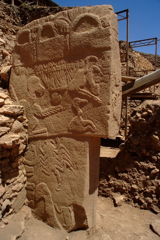
DAI Gobekli Tepe Pillar 43 Sm

It was thought that the site was probably used only in connection with special social events and rituals, but the discovery of domestic buildings and rainwater harvesting systems has caused a revision of the hypothesis. It has now become increasingly clear that people were actually living at Göbekli Tepe and the other Taş Tepeler sites.

The second widely known site, Karahan Tepe, lies roughly 50 km east of Göbekli Tepe; the two are often considered “sister sites”, although some aspects of Göbekli date to slightly earlier. In addition, unlike the on-ground builds at Göbekli Tepe, at Karahan Tepe chambers were carved into the bedrock.

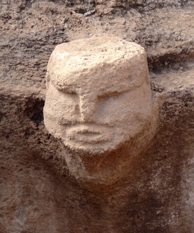
Evidence of domestic (and not just ritual) life at Karahan includes stone troughs, groundstones, mortars, pestles, and handstones. But one of the most striking elements at Karahan is the repetition of human faces, including a face carved from the rock wall of the so-called Pillar Room.
Wikimedia Karahan Tepe Human Face Sm

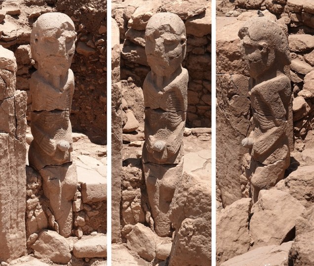
Another famous find at Karahan Tepe is the 2.3-meter-tall statue of a seated man also known as the Ribbed Man. It was carved around 9400 BCE with a defined eyes and nose, a bald head, carefully incised ribs and spine, and hands brought to the front to hold his phallus.
Wikimedia Karahan Tepe Man Sm

A website developed by the Karahan Tepe Research & Archive Project collects visuals and facts of the site, with information also on Göbekli. A timeline at tastepeler.net shows the development of the various sites in relation to other early sites and cultural phenomena.

Both Karahan Tepe and Göbekli Tepe indicate the existence of origanized societies capable of carrying out complex, material- and labor-intensive projects, with their own symbolic worlds and beliefs, before the adoption of farming or pottery. Very deservedly, Göbekli Tepe became a UNESCO World Heritage Site in 2018.

Unfathomably ancient, aren’t they!

Images: map of Taş Tepeler sites via Türkiye Today. Via UNESCO: aerial view of the Göbekli Tepe site and closeup of pillar 43 in Building D by DAI, Göbekli Tepe Project. Building by Frank Samol via Unsplash. Karahan Tepe human face by Frantisek Trampota via Wikimedia (CC SA 4.0). Karahan Tepe man by Marco Restano via Wikimedia (CC BY-SA 4.0).

A Walk through Ur

Here’s a beautiful computer reconstruction of the ancient Mesopotamian city of Ur, focusing on the riverfront and the great ziggurat, created by Zero One for the Melbourne Museum.

The Wonders of Ancient Mesopotamia by Zero One

Hey, look! We found a thing on the internet! We thought it was cool, and wanted to share it with you.

The Rise of the First Cities through Genetic Research

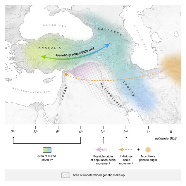
Juan Siliezar at The Harvard Gazette writes about new genetic research into the movement and interactions of inhabitants of different areas of Western Asia and the Levant in the Bronze and Iron Ages. According to the evidence, people traveled and interacted with their neighbors before the rise of cities (and not the other way around as previously thought).

MHAAM Genetic Gradient 6500 BCE

Quoting Siliezar’s article:

“The evidence reveals that a high level of mobility led to the spread of ideas and material culture as well as intermingling of peoples in the period before the rise of cities, not the other way around, as previously thought. The findings add to our understanding of exactly how the shift to urbanism took place.

“The researchers, made up of an international team of scientists including Harvard Professor Christina Warinner, looked at DNA data from 110 skeletal remains in West Asia from the Neolithic to the Bronze Age, 3,000 to 7,500 years ago. The remains came from archaeological sites in the Anatolia (present-day Turkey); the Northern Levant, which includes countries on the Mediterranean coast such as Israel and Jordan; and countries in the Southern Caucasus, which include present-day Armenia and Azerbaijan.

“Based on their analysis, the scientists describe two events, one around 8,500 years ago and the other 4,000 years ago, that point to long-term genetic mixing and gradual population movements in the region.

“’Within this geographic scope, you have a number of distinct populations, distinct ideological groups that are interacting quite a lot, and it hasn’t really been clear to what degree people are actually moving or if this is simply just a high-contact area from trade,’ said Warinner, assistant professor of anthropology in the Faculty of Arts and Sciences and the Sally Starling Seaver Assistant Professor at the Radcliffe Institute for Advanced Study. ‘Rather than this period being characterized by dramatic migrations or conquest, what we see is the slow mixing of different populations, the slow mixing of ideas, and it’s percolating out of this melting pot that we see the rise of urbanism — the rise of cities.’ […]

“Historically, Western Asia, which includes today’s Middle East, is one of civilization’s most important geographical locations. Not only did it create some of humanity’s earliest cities, but its early trade routes laid the foundation for what would become the Silk Road, a route that commercially linked Asia, Africa, and Europe. […]

“The paper outlines how populations across Anatolia and the Southern Caucasus began mixing approximately 8,500 years ago. That resulted in a gradual change in genetic profile that over a millennium slowly spread across both areas and entered into what is now Northern Iraq. […]

“’What’s really interesting is that we see these populations are mixing genetically long before we see clear material culture evidence of this — so long before we see direct evidence in pottery or tools or any of these more conventional archaeological evidence artifacts,’ Warinner said. ‘That’s important because sometimes we’re limited in how we see the past. We see the past through artifacts, through the evidence people leave behind. But sometimes events are happening that don’t leave traces in conventional ways, so by using genetics, we were able to access this much earlier mixing of populations that wasn’t apparent before.’”

Interesting, especially the fact that genetic mixing predates evidence seen in artifacts. Sounds like there’s much to research in the future!

Read more at The Harvard Gazette or see the original article by Lily Agranat-Tamir et al. at Cell.

Found via File 770.

Image: The Max Planck-Harvard Research Center for the Archaeoscience of the Ancient Mediterranean (MHAAM) via Phys.org.

The Ancient Underground City of Derinkuyu

The Derinkuyu (also known as Malakopi) underground city is situated in the historical area of Cappadocia, which is in Central Anatolia in modern-day Turkey. And it’s pretty astounding.

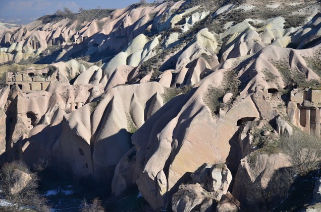
Apparently, underground cities were A Thing thereabouts: according to Wikipedia, there are over 200 of them. Looking at the landscape, it’s no wonder.

Flickr Anthony G Reyes Derinkuyu Pigeon Valley

Much of the rock is easily accessible, i.e., not covered by layers and layers of vegetation, and there are plenty of rock faces to carve into.

The first mentions of underground dwellings in Anatolia come from Xenophon’s Anabasis (c. 370 BCE), but they were probably built much earlier as places of refuge from attacks. Derinkuyu seems to have been in use for millenia: the last recorded use was at least as late as 1909.

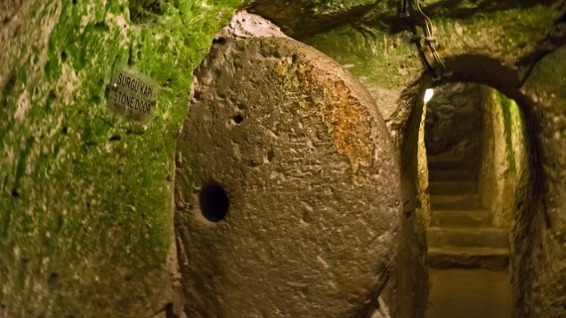
According to a tourism site, there are about 600 entrances to the underground Derinkuyu, and some can be closed with a door resembling a mill stone.

Flickr Dan Merino Derinkuyu Stone Doorway

Underground City in Cappadocia

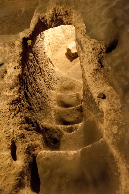
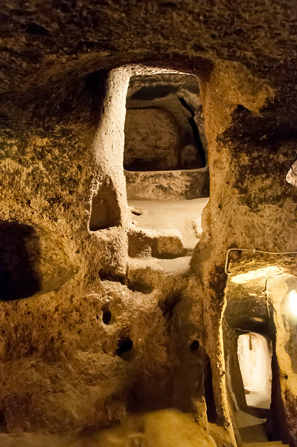
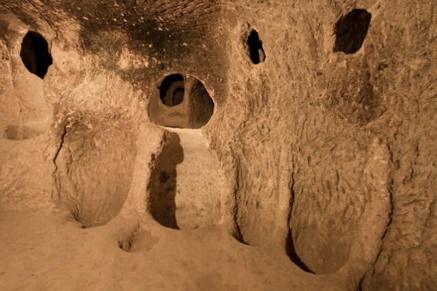
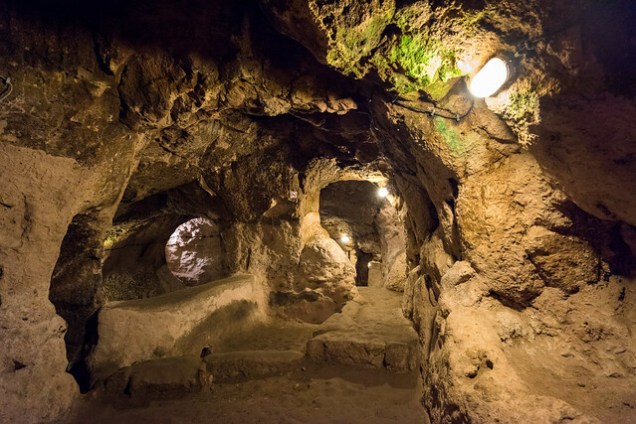
In addition to tunnels and rooms themselves, there are other notable features. There are stairs, ventilation shafts, wells, and storage areas with nooks and crannies of various shapes, including wine troughs.

Underground City in Cappadocia

Flickr Helen Cook Derinkuyu Wine Recepticles

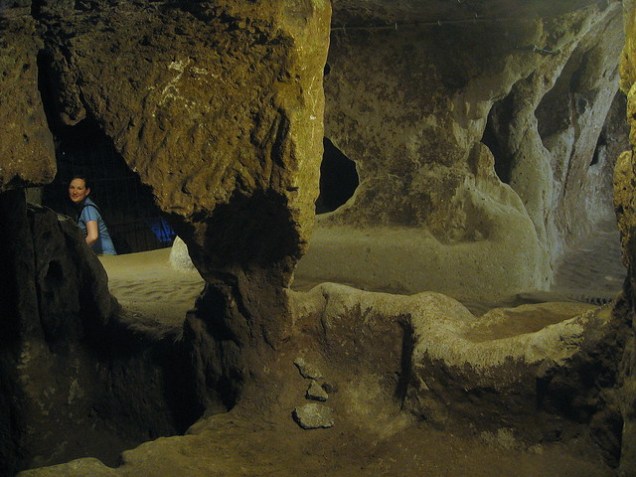
Clearly some areas were left in quite rough shape.

Flickr jyl4032 Derinkuyu Unnamed View

Flickr Patrick Barry Derinkuyu Room w Woman

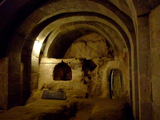
Others were carefully detailed. For example, there is a room with a barrel-vaulted ceiling.

Flickr Takehiko Ono Derinkuyu Vaulted Room

At its largest, Derinkuyu seems to have been able to house 20,000 people and their livestock and supplies.

Found via Ticia Verveer on Twitter.

Images: Cappadocia: Derinkuyu and Pigeon Valley 2015 by Anthony G. Reyes on Flickr (CC BY-ND 2.0). Stone doorway by Dan Merino on Flickr (CC NY-ND 2.0). Stairs down by David Welch on Flickr (CC BY-NC 2.0). Two levels with steps and corridors by David Welch on Flickr (CC BY-NC 2.0). Wine recepticles by Helen Cook on Flickr (CC BY-SA 2.0). Unnamed view of rough corridor by jyl4032 on Flickr (CC BY-ND 2.0). Room with a woman for scale by Patrick Barry on Flickr (CC BY-SA 2.0). Vaulted room by Takehiko Ono on Flickr (CC BY-ND-NC 2.0).

Out There is an occasional feature highlighting intriguing art, spaces, places, phenomena, flora, and fauna.
Western Asian Science Fictional Art

Omar Gilani is an illustrator, designer, and concept artist currently based in Pakistan. Not all of his art has sci-fi elements, but the pieces that do are amazing. Take a look:

Omar Gilani 2
Omar Gilani
Omar Gilani 5
Omar Gilani

The engineer-turned-artist takes inspiration from everyday life and combines traditional drawing with digitally created elements.

Omar Gilani sits4
Omar Gilani
Omar Gilani maybe3
Omar Gilani

I am very sorry I found out about his work only a day(!) after the Hugo nomination period closed. Well, hopefully he’ll continue producing genre art so I can nominate him next year.

Found via Islam and Science Fiction.

This post has been edited.

Out There is an occasional feature highlighting intriguing art, spaces, places, phenomena, flora, and fauna.